High-Resolution Land Data Assimilation System (HRLDAS)
Overview
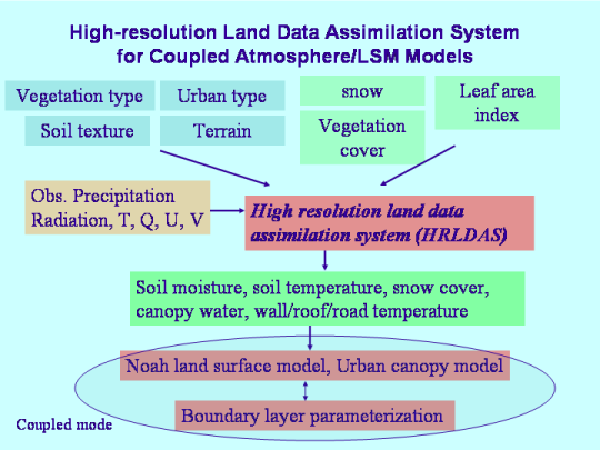
The High-Resolution Land Data Assimilation System (HRLDAS) is an offline driver of the land surface models present in the Weather Research and Forecasting (WRF) model.
HRLDAS uses a combination of observed and analyzed meterological forcing (precipitation, solar and longwave radiation, and surface wind, moisture, temperature) to drive a land-surface model to simulate the evolution of land surface states (e.g., soil moisture and temperature, snow, etc.). The system has been developed to run over WRF domains or over one or more site locations.
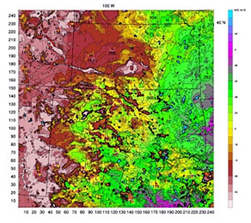
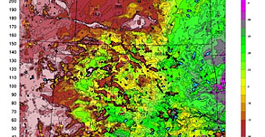
HRLDAS-produced volumetric surface soil moisture at 4-km resolution over the central United States.
The advantage of using HRLDAS as a pre-processor to a WRF simulation is that although the important role of soil moisture in the development of deep-convection has been recognized, it remains the most difficult variable to obtain because there is no routine high-resolution observation of soil moisture at the continental scale. HRLDAS has been developed to fill this gap in the WRF coupled modeling system.
Resources
Publications
-
Description and Evaluation of the Characteristics of the NCAR High-Resolution Land Data Assimilation System
Description
Fei Chen, Kevin W. Manning, Margaret A. LeMone, Stanley B. Trier, Joseph G. Alfieri, Rita Roberts, Mukul Tewari, Dev Niyogi, Thomas W. Horst, Steven P. Oncley, Jeffrey B. Basara, and Peter D. Blanken, 2007: Description and Evaluation of the Characteristics of the NCAR High-Resolution Land Data Assimilation System. J. Appl. Meteor. Climatol., 46, 694–713.
doi: http://dx.doi.org/10.1175/JAM2463.1
Past Releases
We recommend using the most current version. Support is no longer provided for the following past versions.
| Version | Download | Date |
|---|---|---|
| 3.7 | Code: HRLDAS version v4.0 and later release | |
| 3.7.1 | Code: hrldas-release-v3.7.1.gz | Release Notes | GitHub | 2015-Sep |
| 3.7 | Code: hrldas-release-3.7.tar.gz | Release Notes | GitHub | 2015-June |
| 3.6 | Code: hrldas-v3.6.tgz | |
| 3.4.1 | Code: hrldas-v3.4.1.tgz | HRLDAS Users' Guide (PDF) | 2012-Sep |
| 3.4 | Code: hrldas-v3.4-update1.tgz | HRLDAS Users' Guide (PDF) | 2012-Sep |
| 3.3 | Code: hrldas-v3.3.tgz | HRLDAS Users' Guide (PDF) | 2011-Apr |
| 3.2 | Code: hrldas-v3.2.tgz | HRLDAS Users' Guide (PDF) | 2010-Oct |
| 3.1 | Code: hrldas-v3.1.tgz | HRLDAS Users' Guide (PDF) | 2009-May |
| 3.0 | Code: hrldas-v3.0.tgz | HRLDAS Users' Guide (PDF) |