Geographic Information Systems (GIS) Science
Geographic Information Systems (GIS) Science
Read More about the GIS Program
GIS is a science and a technology that includes elements of computer visualization, database management and spatial analysis of geographically referenced data. A GIS stores information as a collection of thematic layers that can be linked together by geography. In many disciplines and sectors GIS is used for data integration, spatial analysis and decision making.
The GIS Program is an interdisciplinary effort to foster collaborative science, spatial data interoperability, and knowledge sharing with GIS
The GIS program at the National Center for Atmospheric Research (NCAR) is an interdisciplinary effort to foster collaborative science, spatial data interoperability, and knowledge sharing with GIS. Working toward the definition, standards and interoperability of atmospheric information for usable science, the GIS program is:
- Conducting research integrating the Earth system and social sciences through spatial analysis and interoperability of georeferenced information
- Supporting the use of GIS as both an analysis, and an infrastructure tool in atmospheric research
- Improving usable science and knowledge sharing between science groups, educators and stakeholders
- Addressing broader issues of spatial data management, interoperability, and geoinformatics within the geosciences
Research
Our research activities focus on integrating the Earth system and social sciences through spatial analysis and interoperability of georeferenced information. Ongoing work in the GIS program includes:
- methodological development for coupling social and natural sciences through integration of quantitative and qualitative data in a GIS
- improving spatial accuracy and usability of atmospheric models for terrestrial and societal applications
Research progress in integration of geographic and atmospheric information allows us to conduct and support a variety of research projects at NCAR, where spatial analysis and accurate georeferenced data are critical to answering complex scientific questions. With more than one hundred GIS users in all NCAR laboratories, the projects range from atmospheric chemistry to societal impacts of climate change to homeland security.
Resources
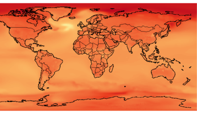
The GIS Climate Change Scenarios project, conducted by the GIS program in collaboration with the engineering team at NCAR's Community Data Portal, serves a large community of GIS users interested in global climate change. This data portal provides access to global and downscaled data sets of climate change scenarios generated for the IPCC AR4 by the Community Climate System Model (CCSM–3). The model outputs can be viewed on-line or downloaded in a GIS format, thus allowing for easy integration of climate projections with environmental and socio–economic datasets. To–date, more than 3500 users from 133 countries have accessed the CCSM–3 climate predictions through the GIS data portal. Climate change analysis products (e.g., seasonal and annual averages, climate anomalies) will be added for distribution through the GIS portal in 2010.
Model results from CCSM are converted to GIS–compatible formats for distribution to the GIS user community via a public website. This application, across projects and models, puts detailed climate change information in the hands of decisionmakers, educators and researchers.
Community
Community and capacity building through GIS–focused education, creation of aus usable GIS lab, and engaging with a broader community through workshops and conferences are important aspects of GIS program. Three community workshops conducted in 2002, 2005, 2008 on GIS in weather, climate and impacts have been instrumental in defining research agenda for the AtmoGIS community and in building collaborations.
Featured Tools


Contact
Olga Wilhelmi
Head of GIS Program