Weather Guidance for Uncrewed Aircraft Systems (UAS)
Hazard Detection and Forecasting Capabilities

Weather Guidance for Uncrewed Aircraft Systems (UAS)
Hazard Detection and Forecasting Capabilities
The age of uncrewed systems is upon us, both in the skies and on our highways! The number of small (weighing between 0.55 and 55 lbs) commercial Uncrewed Aircraft Systems (UAS)operating over the U.S. is expected to increase exponentially with time, potentially exceeding 1.6 million by 2021. The Federal Aviation Administration (FAA), NASA, NCAR, and industry leaders are working toward enabling the safe integration of UAS into the National Airspace (NAS) in support of developing a UAS Traffic Management (UTM) system. A key component of integrating UAS into the NAS is to demonstrate their safe flight in the presence of hazardous weather conditions. To meet this goal, NCAR is coupling the latest weather technologies with new algorithms that translate detailed weather information into UAS-specific performance impacts. These new systems can be tailored for specific UAS applications to aid in both flight planning and in-flight decision making.
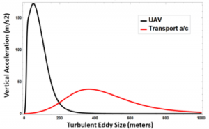
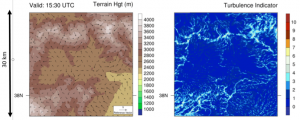
Because of their light weight, slower air speed and limited endurance, most small UAS are much more susceptible to variations in wind speed/direction and turbulence occurring on much finer scales than that impacting commercial aircraft (FIG 1). Sudden changes in wind speed and direction can render small UAS unrecoverable if the resulting head winds exceed performance characteristics. At the same time, UAS trying to maintain level/smooth flight in areas of more intense turbulence can run out of power more quickly than anticipated. In an attempt to mitigate these operational constraints, NCAR has developed a fine-scale realtime modeling capability that can be used to provide guidance on fine-scale variability of winds, as well as the location, intensity and duration of turbulence hazards as shown in FIG2. This new capability will be demonstrated during ISARRA (International Society for Atmospheric Research using Remotely-piloted Aircraft) Flight Week in July 2018 (NCAR UAS Weather Display). Wind and turbulence data collected during coordinated flight missions will be used to evaluate and improve the model.
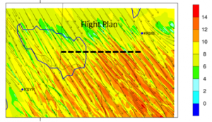
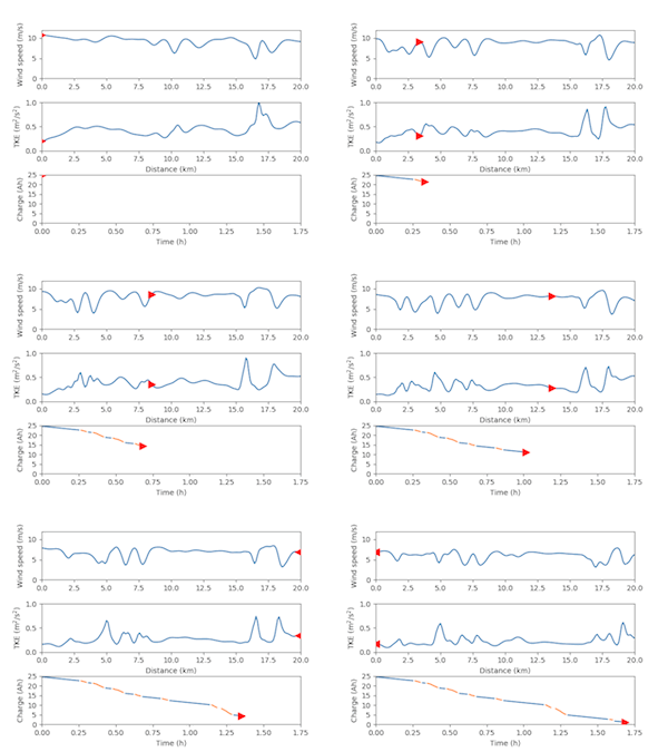
Finally, translation models are being developed to assess the impact of forecasted winds and turbulence along a user-define flight path on battery usage (FIG 3). The movie shown in Figure 3 demonstrates how wind speed and turbulence along the planned trajectory are expected to change during the planned flight period. It also provides a prediction on how the battery will be depleted. The aircraft position is depicted with a red triangle. It indicates the position of the aircraft at 1 min increments along the planned flight path along with the expected wind speed and turbulence. The ground speed of the UAS is computed by factoring in the predicted head wind along the planned flight path. The outbound leg takes 3X longer to complete than the inbound leg due to the forecasted headwinds. In addition, sporadic episodes of more intense turbulence along both legs result in an additional drain on the battery. This information can be used by operators for flight planning and UTM to determine routing structures and UAS spacing along flight routes.
Learn More and Register Here for our UAS Weather Forum Event!
Publications
-
Efficient graphics processing unit modeling of street-scale weather effects in support of aerial operations in the urban environment
Description
D. Muñoz-Esparza, H.H. Shin, J.A. Sauer, M. Steiner, P. Hawbecker, J. Boehnert, J.O. Pinto, B. Kosović, R.D. Sharman, Efficient graphics processing unit modeling of street-scale weather effects in support of aerial operations in the urban environment. AGU Advances, vol. 2 (2021) https://doi.org/10.1029/2021AV000432
-
The status and future of small uncrewed aircraft systems (UAS) in operational meteorology
Description
Pinto, J. O., J. Elston, D. O'Sullivan, B. Baker, J. Jacob, S. Taylor, G. Roberts, K. Barfuss, B. Piguet, C. Marshall, M. Steiner, N. Omanovic, and M. Fengler, The status and future of small uncrewed aircraft systems (UAS) in operational meteorology, Bulletin of the American Meteorological Society, 102(11), E2121–E2136, 2021. https://doi.org/10.1175/BAMS-D-20-0138.1
-
Real-time WRF large-eddy simulations to support uncrewed aircraft system (UAS) flight planning and operations during 2018 LAPSE-RATE
Description
Pinto, J. O., A. A. Jensen, P. A. Jimenez, T. Hertneky, D. Muñoz-Esparza, A. Dumont, and M. Steiner, Real-time WRF large-eddy simulations to support uncrewed aircraft system (UAS) flight planning and operations during 2018 LAPSE-RATE, Earth System Science Data, 13(2), 697 – 711, 2021. https://doi.org/10.5194/essd-13-697-2021
-
Assimilation of a coordinated fleet of uncrewed aircraft system observations in complex terrain: ENKF system design and preliminary assessment
Description
Jensen, A. A., Pinto, J. O., Bailey, S. C. C., Sobash, R. A., De Boer, G., Houston, A. L., … Steiner, M. (2021), Assimilation of a coordinated fleet of uncrewed aircraft system observations in complex terrain: ENKF system design and preliminary assessment. Monthly Weather Review, 149, 1459-1480, 2021. https://doi.org/10.1175/MWR-D-20-0359.1
-
Assessment of finescale local wind forecasts using small unmanned aircraft systems, Journal of Aerospace Information Systems
Description
Glasheen, K., J. Pinto, M. Steiner, and E. Frew, Assessment of finescale local wind forecasts using small unmanned aircraft systems, Journal of Aerospace Information Systems, 17(4), 182 – 192, 2020. https://doi.org/10.2514/1.I010747
-
Air Support: Creating a data-rich future with aeronautical weather sensors
Description
Robinson, M., Fronzak, M., Becher, T., Steiner, M., Air Support: Creating a data-rich future with aeronautical weather sensors. Meteorological Technology International, 2020. https://www.ukimediaevents.com/publication/b853e52b/48
-
Urban air mobility – Opportunities for the weather community
Description
Steiner, M., Urban air mobility – Opportunities for the weather community, Bulletin of the American Meteorological Society, 100(11), 2131 – 2133, 2019. https://doi.org/10.1175/BAMS-D-19-0148.1
-
Tradeoffs for routing flights in view of multiple weather hazards
Description
Sauer, M., M. Steiner, R. D. Sharman, J. O. Pinto, and W. K. Deierling, Tradeoffs for routing flights in view of multiple weather hazards, Journal of Air Transportation, 27(2), 70 – 80, 2019. https://doi.org/10.2514/1.D0124
-
Flight Planning and Execution With Multiple Weather Hazards
Description
Sauer, M., M. Steiner, R. D. Sharman, J. O. Pinto, and D. R. Adriaansen, Flight Planning and Execution With Multiple Weather Hazards, The Journal of Air Traffic Control, 58(4), 16 – 23, 2016.
Contact
James Pinto
Deputy Director Science, Aviation Applications Program
