WRF-Hydro Application for National Water Availability Assessment (NWAA)
A Comprehensive Retrospective Analysis of Water Availability Across the CONUS

By Arezoo RafieeiNasab, Water Cycle Applications Program
The U.S. Geological Survey (USGS), in partnership with the NSF NCAR WRF-Hydro® team, has completed an extensive retrospective assessment of water availability across the contiguous United States (CONUS). Building on the recently released CONUS404 dataset, the collaboration produced hydrologic simulations covering more than four decades, enabling detailed analyses of long-term events such as droughts as well as broader trend evaluations. In addition, the newly finished CONUS404-PGW simulation provides a framework for exploring alternative future scenarios of water availability affecting agriculture, energy production, municipal supply, and ecosystems. Together, these advances inform critical research on how climate variability influences fine-scale processes and offer valuable insights for managing water resources in the future.
Background
Water availability is crucial for sustaining life, supporting ecosystems, and driving economic development. However, the balance between water supply and demand is increasingly strained due to factors such as climate variability, pollution, and over-extraction. The USGS National Water Availability Assessment (NWAA) is a comprehensive national initiative intended to evaluate water availability in the United States (US). To enable continuous, nationwide analysis—even in regions with sparse observational data—two national-scale hydrological models, PRMS and WRF-Hydro®, were employed. Results from the modeling and assessment are available in the recently published USGS report and data companion.
Bias-Adjusted CONUS404
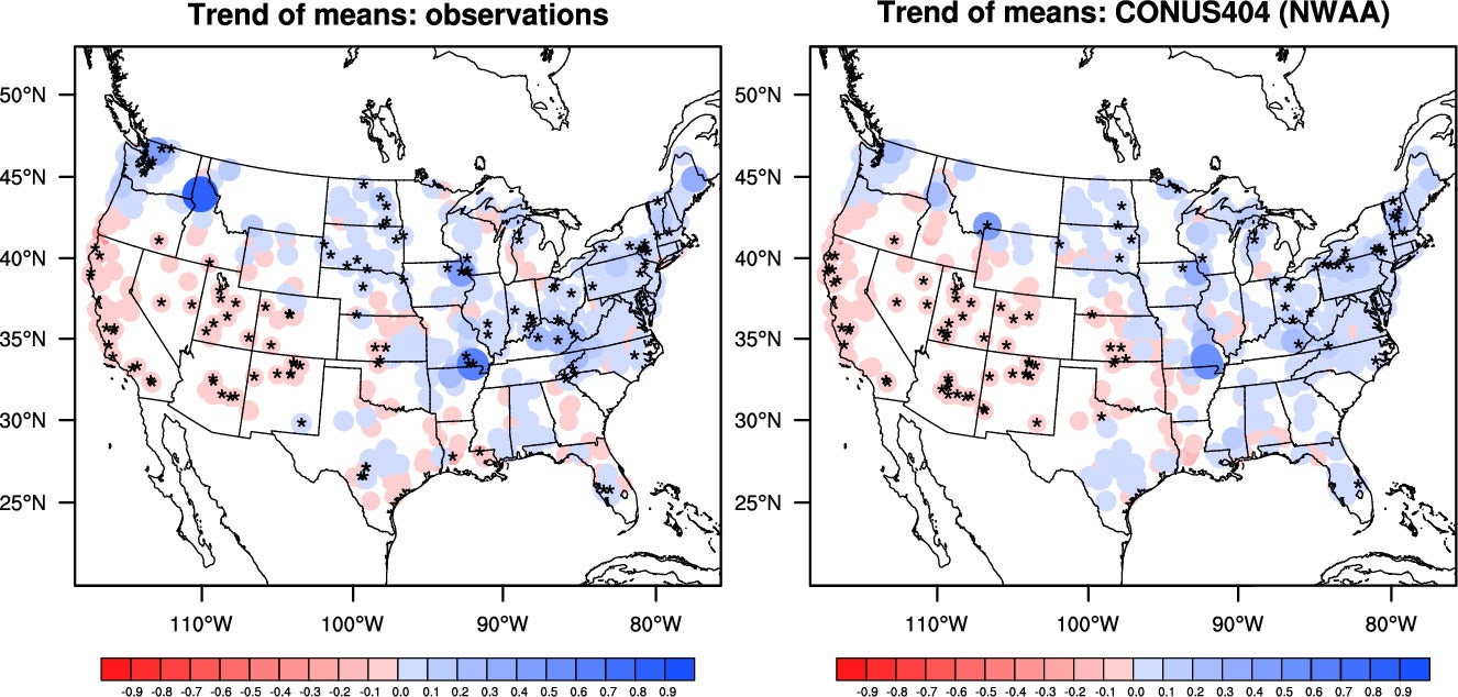
Trends (cms/year) of streamflow means at 562 USGS reference gauge from observations (left) and NWAA driven by bias-adjusted CONUS404 (right) over WY1980-WY2022. The color scheme is from -0.9 to 0.9 with an interval of 0.1. The size of the circle is proportional to the magnitude of the trend. The stars represent statistically significant trends at 0.1 significance level.
Provided by Yongxin Zhang - "Spatiotemporal distributions of streamflow extremes over the Continental U.S. during the past four decades in the observations and WRF-Hydro simulations" publication in progress
The modeling applications used to support the NWAA are forced by the state-of-the-art CONUS404, a regional hydroclimate dataset over the CONUS. CONUS404 provides 40+ years of data at a spatial resolution of 4 km across CONUS. Through better representation of fine-scale weather phenomena, such as mesoscale convective systems and orographic precipitation, CONUS404 can produce a relatively accurate distribution of rainfall and temperature over a large area and a long time period. Initial assessment of the CONUS404 dataset revealed some regional biases that could introduce inaccuracies in the hydrologic modeling. Therefore, the CONUS404 dataset air temperature and precipitation fields were bias-adjusted and then used to force the NWAA hydrologic applications. These data are publicly available at Zhang et al. 2024.
WRF-Hydro® NWAA Simulations
The WRF-Hydro® model was calibrated using USGS streamflow observations and forced by the bias-adjusted CONUS404 dataset. The model was run at a spatial resolution of 1 km for the land-surface model and 250 meters for lateral surface and subsurface routing, followed by groundwater, and channel routing on ~2.7 million NHDPlus catchments and reaches. The project was executed in two phases. In the first phase, a 12-year dataset was released publicly (Rafieeinasab et al. 2024) and used to assess current water availability, with results summarized in the recent USGS report. In the second phase, a 43-year model simulation extending from October 1979 to October 2023 was completed and made available at Rafieeinasab et al. 2024. This longer simulation is being used to evaluate trends in water availability and their drivers.
For more information, contact: wrfhydro@ucar.edu