19186285.jpg

Water Systems Program (WSP)

Examining the impact of a changing water system on water management and policy

The NCAR Water System Program (WSP) is a cross-Laboratory program that aims to improve understanding of the current water cycle and its likely evolution in a future climate by conducting research in the following areas: 

  1. Global analysis and diagnosis of the water cycle from satellite and climate models,
  2. Regional analysis of the water cycle using high resolution climate simulations over the Colorado Headwaters and U.S. CONUS,
  3. Observations and simulation of Mesoscale Convective Systems, 
  4. Improving the representation of land-surface/hydrology processes in the community land surface models (NoahMP and the Community Land Model (CLM)). 

In addition, two hydrological community models—WRF-Hydro and Structure for Unifying Multiple Modeling Alternatives (SUMMA)—have been developed in collaboration with the US Bureau of Reclamation, US Army Corps of Engineers, and NOAA. A short description of these models follows the discussion of the research themes.

1. Global analysis and diagnosis of the water cycle from satellite and climate models 

Figure 1. Multi-model mean long-term percentage changes from 1970–1999 to 2070–2099 (under a moderate RCP4.5 scenario) over land in annual (a) precipitation, (b) soil moisture content in the top 10cm layer, (c) surface evapotranspiration, and (d) total runoff from 31-33 CMIP5 models. The stippling indicates at least 80% of the models agree on the sign of change. (From Dai 2016, AGU Monograph)

Global WSP-related research has primarily focused on precipitation characteristics (amount, frequency, intensity and duration) and how they are simulated by climate models, although studies focusing on continental runoff, drought, and regional and global water and energy budgets have also been undertaken. The WSP research on the global water cycle has made significant contributions in understanding 1) characteristics of climate-model simulated precipitation; 2) historical and future changes in precipitation, streamflow and continental runoff (fig. 1); 3) regional and global water and energy budgets; and 4) historical and future changes in global drought. Besides publishing a number of influential and highly- cited papers, the WSP has produced several global datasets that have been widely used by the university community and other groups, such as a revised Palmer drought severity index (PDSI) dataset and global streamflow and discharge dataset. This work also involves collaboration with faculty and graduate students from a number of universities.

2. Regional analysis of the water cycle using high resolution climate simulations over the Colorado Headwaters and U.S. CONUS

The Colorado Headwaters effort was initiated in the spring of 2008 as a project within the NCAR Water System program. It has focused on assessing the impact of climate change on winter precipitation, snowpack and runoff processes in Colorado's headwater basins using a very high- resolution fully-coupled atmospheric–hydrologic model (WRF coupled with the Noah land surface model). This work is collaborative with researchers from the University of Vienna, George Mason University, and the University of Texas.  A paper published from this effort showed that accurate simulation of Colorado snowfall and snowpack required a minimum horizontal model resolution of 6 km and that future snowpack melted 2-3 weeks earlier in a future climate despite the potential for 10-15% more snowfall in winter.  This Journal of Climate paper received the UCAR Outstanding Publication  award in December 2015. 

CONUS Simulations: The Colorado Headwaters high-resolution climate modeling effort has been expanded to cover all of North America.  Thirteen years of current and future simulations have been completed at 4 km horizontal resolution. The model faithfully reproduces the observed precipitation and snowpack in most regions of the U.S.  The output of these model runs will be used by WSP and university scientists to examine snowfall and snowpack changes in a future climate, as well as convection in the central U.S. and hurricanes in the Gulf of Mexico. A journal paper has been published in Climate Dynamic about the dataset and to advertise its availability to the community. 

Liu, Changhai, Kyoko Ikeda, Roy Rasmussen, Michael Barlage, A. J. Newman, A. F. Prein, F. Chen, L. Chen, Martyn Clark, Aiguo Dai, Jimy Dudhia, Trude Eidhammer, David Gochis, Ethan Gutmann, Sopan Kurkute, Yanping Li, Gregory Thompson, David Yates, 2016:  Continental‑scale convection‑permitting modeling of the current and future climate of North America, Climate Dynamics, DOI 10.1007/s00382-016-3327-9. 

Access to the data can be gained through the following portal (web site or DOI): 

3. Observations and simulation of Mesoscale Convective Systems

The WSP global model diagnostic studies revealed that most global climate models do not capture the nocturnal maximum in precipitation associated with eastward propagating Mesoscale Convective Systems  in the central U.S.  These systems are important as they produce a significant fraction of the annual precipitation in these regions. To understand the dynamics and forcing of these systems, WSP scientists have used the WRF community model to conduct a variety of studies.  The most recent work considered a 12-day heavy precipitation corridor in the central U.S., where warm-season precipitation was confined to narrow latitudinal zones (~3-4°). 

Model sensitivity studies revealed important positive feedbacks to corridor persistence resulting from moistening of the tropospheric column and from daytime sensible heat flux gradients (owing to residual cloudiness), which enhanced the lower-tropospheric frontal zone where the nocturnal corridor precipitation occurred. However, additional sensitivity studies revealed that corridor persistence was most affected by large-scale external factors. Current work is focused on analyzing these systems in the 13-year CONUS simulations. Insights from this work are communicated to the research community via papers and are expected to benefit both regional and global climate modeling research. At NCAR, CGD scientists are using it to help understand and improve the simulation of nocturnal thunderstorms in the Community Atmospheric Model (CAM). 

4. Improving the representation of land-surface/hydrology in the Community Land Surface Models

WSP research is focused on improving the representation of land-surface and hydrologic processes in Earth System Models. The Noah and NoahMP land surface models are two of the most commonly used land surface parameterizations in the community WRF modeling system and in the suite of operational models at NCEP/NOAA.  The NoahMP model is also the core column land surface model operating within the new National Water Model.  The WSP, through its regional water cycle research activities and collaborations with university investigators, NASA, and NOAA groups, has contributed to several major enhancements to both the Noah and NoahMP model, particularly with regard to improving the representation of snowpack, soil hydrology, vegetation canopy structure and surface energy fluxes. Members of the NCAR WSP organize and participate in annual land model workshops to coordinate Noah/NoahMP research and development activities with the academic and agency communities. WSP scientists are working with NCEP collaborators to implement the enhanced NoahMP land model in NCEP GFS and CFS in order to improve our nation’s global and seasonal prediction capabilities.

NCAR WSP scientists have partnered with the Consortium of Universities for the Advancement of Hydrologic Sciences Incorporated (CUAHSI) to use the NCAR Community Land Model (CLM) as a vehicle for hydrologists to engage in community modeling. This effort has supported strong and effective collaboration among NCAR scientists and the university community, including contributions to the code development in CLM5 (using some concepts from SUMMA to improve simulations of the storage and transmission of water through soils). A community workshop was held at NCAR in October 2015, and the project team is now actively working to incorporate advanced representations of lateral subsurface flow processes in CLM.

Community Hydrological Modeling

A cornerstone of the NCAR Water Systems program is the development and support of community modeling tools for both process-based research and hydro-meteorological forecasting applications.  These tools are co-developed by NCAR in close collaboration with university researchers and government agencies in the U.S. and around the world.  Scientists from the NCAR WSP serve as focal points for training and collaboration in the hydro-meteorological community.

SUMMA Community Model

Figure 2 Conceptual diagram illustrating a framework for supporting multiple alternative model options for a range of physical processes, integrated as part of a common numerical solver.

Efforts on modeling the terrestrial component of the water cycle have focused on developing a unified approach to land modeling. A major recent accomplishment is the development, publication, and release of a new modeling framework termed SUMMA (the Structure for Unifying Multiple Modeling Alternatives), available for download from the NCAR-wide gitHub source code repository.  SUMMA is a next-generation hydrologic model, providing multiple options to simulate all dominant biophysical and hydrologic processes from the treetops to the stream (Figure 2). SUMMA provides a master modeling template from which existing hydrologic and land models can be derived, providing multiple options for the spatial configuration, process parameterizations, and time stepping schemes. The overall intent of SUMMA is to help modelers select among modeling alternatives (to improve model fidelity) and pinpoint specific reasons for model weaknesses (to better characterize model uncertainty and prioritize areas needing more research and development). SUMMA is beginning to see widespread use and is a core component of many new projects with university partners.

The unified approach to modeling advanced in SUMMA directly addresses the current divergence in land modeling efforts, and is deliberately designed to foster greater engagement in community modeling efforts. Specifically, the flexible structure of SUMMA simplifies sharing of code and concepts across different model development groups, for example, facilitating rapid experimentation with different flux parameterizations and spatial configurations. The flexible structure of SUMMA also streamlines efforts to tailor the model to suit specific science questions and applications. More generally, this unified approach to land modeling provides new opportunities for Earth System scientists to “plug in” to community modeling efforts, enabling members of the modeling community to pool resources, learn from each other, and accelerate modeling efforts.

WRF-Hydro Community Model

The community WRF-Hydro system is a comprehensive terrestrial water cycle modeling system, integrating community advances in land modeling, hydraulic routing, data assimilation, and water management (see Figure 3).  The SUMMA unified model is being used to help inform future spatial configurations and process parameterizations used in the WRF-Hydro system. WRF-Hydro has been developed and supported by NCAR in collaboration with multiple partners in the U.S. and international academic communities, U.S. federal agencies, and members of the private sector. It is available to community researchers via download from an NCAR web site and is supported via tutorials and workshops.  Version 3 of WRF-Hydro was released in May of 2015 with several new test cases and model pre-processing tool.

Development and Implementation of the WRF-Hydro System as the National Weather Service National Water Model (sponsored by NOAA)

Figure 3. Integration of community hydrologic modeling advances into the WRF-Hydro system. A key recent application is the configuration of WRF-Hydro as the National Water Model for the USA National Weather Service.

In April 2015, WRF-Hydro was selected by the NOAA National Water Center (NWC) for implementation as a new National Water Model (NWM) for operational hydrologic analysis and prediction for the U.S.  The NWM will provide real-time accounting and prediction of the total state of water in the nation and translate severe weather information into actionable, ‘street-level’ hydrologic impacts information for real-time decision making.  Working closely with NOAA under an accelerated development and implementation schedule, NCAR is now transitioning the model to operational use.

The modeling system represents the first-in-time operationalization of a ‘hyper-resolution’ (sub 1km), multi-scale terrestrial hydrologic modeling system for the nation.  WRF-Hydro/NWM will provide, several times per day, analyses and forecasts of terrestrial hydrological conditions at 250 meters and river channel flow and velocity conditions at over 2.7 million river reaches across the country.

Figure 4: (left panel) Example of river channel flow conditions in 2.7 million channel reaches from the WRF-Hydro/NWM system resulting from the heavy rainfall in southeast Texas during late May 2015. (right panel) Example map of simulated surface inundation flooding near Houston, Tx. during the same event. Black lines-state borders, grey lines-counties, red lines-U.S Interstates. Colorscale ranges from 0-800 mm

The broader impacts of this effort are expected to be profound.  Currently the NWS provides as-needed streamflow forecast service at nearly 4,000 pre-defined forecast points using empirically tuned watershed models. The advent of the new WRF-Hydro/NWM will provide spatially- and temporally-continuous, physics-based, forecast service across the entire nation and through all of its waterways at spatial scales which permit detailed decision making for high-impact hydrologic events and water resources management. [See Figure 4 below for a prototype graphic from the WRF-Hydro/NWM]. 

When the model becomes operational in June 2016, all real-time model outputs, approximately 3Tb of data per day, will be made publically available. As an open-source community-based, supported modeling system, WRF-Hydro provides a clear and open pathway for the academic community, as well as the public and private sectors, to contribute to its continued development and to create new value-added products and services. As such the WRF-Hydro NWM represents a major step forward in the equitable, free and open provision of model code, source data and operational outputs to the world and, according to NWC staff, is expected to revolutionize water forecasting products and services here in the U.S. and abroad.

Partners

  • GEWEX
  • George Mason University
  • U.S. Army Corps of Engineers and Bureau of Reclamation
  • University of Texas
  • University of Vienna

Publications

Musselman, K.N., F. LehnerK. IkedaM. ClarkA. PreinC. LiuM. Barlage and R. Rasmussen, Projected increases and shifts in rain-on-snow flood risk over western North America (2018), Nature Climate Change, 8, pp. 808–812.

Gutmann, E., R.M. Rasmussen, C. Liu, K. Ikeda, C.. Bruyere, J. Done, L. Garre, P. Friis-Hansen, V. Veldore (2018): Changes in Hurricanes from a 13 Year Convection Permitting Pseudo-Global Warming Simulation, J. Climate, D-17-0291.

Eidhammer, T., V. Grubišić, R.Rasmussen, & K. Ikeda (2018). Winter precipitation efficiency of mountain ranges in the Colorado Rockies under climate change. Journal of Geophysical Research: Atmospheres, 123. https://doi.org/10.1002/2017JD027995

Liu, C., K. Ikeda., R. Rasmussen, M. Barlage, A. J. Newman, A. F. Prein, F. Chen, L. Chen, M. Clark, A. Dai, J. Dudhia, T. Eidhammer, D. Gochis, E. Gutmann, S. Kurkute, Y. Li, G. Thompson, D. Yates, 2017:  Continental‑scale convection‑permitting modeling of the current and future climate of North America, Climate Dynamics, DOI 10.1007/s00382-016-3327-9.

Prein, A.F., C. Liu, K. IkedaS. TrierR. Rasmussen, G. Holland, M. Clark, Increased rainfall volume from future convective storms in the US, ,,,2017:  Nature Climate Change, 2017, 7, 880–884, , doi:10

Rasmussen, K. L., A. F. Prein, R. M. Rasmussen, K. Ikeda, and C. Liu, 2017: Changes in the convective population and thermodynamic environments in convection-permitting regional climate simulations over the United States. Climate Dynamics, https://doi.org/10.1007/s00382-017-4000-7.1038/s41558-017-0007-7

Prein, A. F., G. J. Holland, R. M. Rasmussen and M. P. Clark, 2017: The future intensification of hourly precipitation extremes. Nature Climate Change, 7, 48-52.

Prein AF, C Liu, K Ikeda, R Bullock, RM Rasmussen, GJ Holland, M Clark (2017) Simulating North American Mesoscale Convective Systems with a Convection Permitting Climate Model. Climate Dynamics. doi:10.1007/s00382-017-3947-8

Dai, A., RM Rasmussen, C Liu , K Ikeda , AF Prein (2017) A new mechanism for warm-season precipitation response to global warming based on convection-permitting simulations. Climate Dynamics, DOI 10.1007/s00382-017-3787-6.

Dai, A., R.M. Rasmussen, K. Ikeda, and C. Liu (2017) A new approach to construct representative future forcing data for dynamic downscaling. Climate Dynamics, DOI 10.1007/s00382-017-3708-8

Prein AF, RM Rasmussen, G Stephens (2017) Challenges and Advances in Convection-Permitting Climate Modeling. BAMS; doi:10.1175/BAMS-D-16-0263.12/5

Prein AF, RM Rasmussen, K Ikeda, C Liu, M Clark, GJ Holland (2017) The future intensification of hourly precipitation extremes. Nature Climate Change; 7(1):48–52; doi:10.1038/nclimate3168

Liu C, K Ikeda, RM Rasmussen, M Barlage, AJ Newman, AF Prein et al. (2017), Continental-scale convection-permitting modeling of the current and future climate of North America. Climate Dynamics, doi:10.1007/s00382-016-3327-9

Musselman, K.N., M. P. Clark, C. Liu, K. Ikeda and R. Rasmussen (2017), Slower snowmelt in a warmer world. Nature Climate Change. 7(3), 214-219. DOI: 10.1038/nclimate3225

Scafe et al. 2018: Simulating the diurnal cycle of convective precipitation in North America's current and future climate with a convection-permitting model, In review at Climate Dynamics.

Letcher, T.W., J.R. Minder, 2017: The simulated impact of the snow albedo feedback on the large-scale mountain-plain circulation east of the Colorado Rocky Mountains. Journal of the Atmospheric Sciences, (Accepted for publication)

Minder, J.R., T.W.* Letcher, C. Liu, 2017: The character and causes of elevation-dependent warming in high-resolution simulations of Rocky Mountain climate change. Journal of Climate (Accepted for publication)

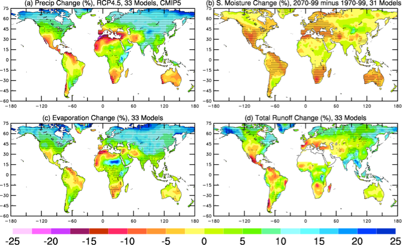
Rasmussen, R.M., K. Ikeda, M. Clark, C. Liu, F. Chen, M. Barlage, A. Newman, E. Gutmann, J. Dudhia, D. Gochis, A. Dai and K. Musselman, 2018: Snowfall and Snowpack Future Trends in the Western U.S. as Revealed by a Convection Resolving Climate Simulation. (To be submitted to J. Climate)

Rasmussen, R. M., C. Liu, K. Ikeda, D. Gochis, D. Yates, F. Chen, M. Tewari, J. Dudhia, W. Yu, K. Miller, K. Arsenault, V. Grubišic, G. Thompson, E. Gutmann, and R. Carbone, 2009: High Resolution Simulation of Seasonal Snowfall over Colorado and some Impacts of Climate Change. To be submitted to J. of Climate.

Ikeda, K., R. M. Rasmussen, C. Liu, D. Gochis, D. Yates, F. Chen, M. Tewari, M. Barlage, J. Dudhia, W. Yu, K. Miller, K. Arsenault, V. Grubišic, G. Thompson, E. Gutmann, and R. Carbone, 2009: Simulation of Seasonal Snowfall over Colorado. Submitted to Atmos. Research.

Representative Projects

  • Assessing the Viability of Over-the-Loop Streamflow Forecasting: The U.S. Army Corps of Engineers and Bureau of Reclamation sponsored a project to evaluate the viability of science-based techniques and strategies for real-time hydrologic flood and drought forecasting for real-time water decisions
  • Colorado Headwaters: The Colorado Headwaters effort was formed to assess the impact of climate change on  precipitation, snowpack and runoff processes in Colorado's headwater basins using a very high-resolution fully coupled atmospheric–hydrologic model
  • CONUS Downscaling: Statistical downscaling for CONUS: Improving the model 
  • Contiguous United States (CONUS) High-Resolution Climate Modeling: Assessed how physical processes such as precipitation, snowfall, snowpack, runoff, and evapotranspiration are influenced by climate change in the Contiguous United States (CONUS) using high-resolution climate modeling
  • Global Water Cycle and Drought: Modeled and analyzed the global water cycle and drought patterns
  • South America: Conducted Research and discovered patterns and features of the water and energy cycle of South America

Contact

Roy Rasmussen

Director, Hydrometeorology Applications Program

email