Fine-Scale Analysis and Nowcast System (FINECAST®)
FINECAST® Nowcasting System: High Resolution Analysis
Improving Nowcasting via Data Assimilation
Fine-Scale Analysis and Nowcast System (FINECAST®) is used by the research community to study convective weather-initiation mechanisms, as well as by the operational community to improve nowcasting. Since 1998, FINECAST® has been implemented in real time for severe-weather nowcasting, wind-energy prediction, hazardous-chemical detection, and model initialization. The code is fully parallelized by a MPI (Multiple Processing Interface) to handle the computation demand of the 4DVar scheme so that each analysis can be produced in a few minutes with an update frequency of 10 minutes to meet the nowcasting requirement.
High-density and frequent observations
Scientists and engineers developed the fine-resolution analysis and nowcasting system, named FINECAST® (previously known as Variational Doppler Radar Analysis System), based on high-density and frequency observations, such as those from Doppler radars and surface networks. The core technology of FINECAST® is a 4-dimensional variational (4DVar) data-assimilation system within a convection-permitting model. By making use of the observations at more than one-time levels, the model trajectory of a specified time window is fitted to the observations and meteorological analyses of observed and unobserved variables. These analyses could not otherwise be obtained from operational NWP models because they are primarily based on large-scale observations.
HIGH-RESOLUTION ANALYSIS
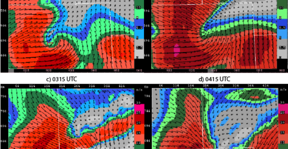
Rapidly updated high-resolution meteorological analysis is a key requirement for accurately forecasting hazardous weather events. Operational Doppler radar networks provide temporally and spatially high-resolution observations, but they are limited to radial wind and reflectivity. Variables of 3-dimensional wind, temperature, and microphysics that provide the whole picture must be retrieved from these limited observations.
3D PICTURE OF CONVECTIVE STORMS
A critical step toward improved nowcasting capability for convective storms is understanding their initiation and evolution mechanisms. FINECAST® helps researchers and forecasters identify thunderstorm predictors and develop conceptual models for convective-weather nowcasting. By fitting model trajectories to observations using the 4DVar technique, dynamically consistent meteorological fields are retrieved.
From these retrieved fields, dynamical and thermodynamical diagnostic fields, such as divergence, updraft/downdraft, CAPE, CIN, vertical wind shear, perturbation temperature (cold pool), helicity, etc., can be derived, essential for characterizing and predicting convective storms. These diagnostic fields provide depictions of the mesoscale environment, the triggering mechanism, and the structure of convective storms. Some of these fields are being used in AutoNowcaster to identify regions of convective initiation.
NOWCASTING WIND & PRECIPITATION
The analysis fields produced by FINECAST® are also used to initialize Numerical Weather Prediction (NWP) models to improve precipitation and wind nowcasts. FINECAST® analyses are initial conditions for the cloud model used in FINECAST® that constrain the 4DVar analyses, from which nowcasts can be launched by directly integrating the cloud model. FINECAST® analyses have also been used to initialize other non-hydrostatic models, such as WRF (Weather Research and Forecasting).
FINECAST® is being studied for its ability to address the challenges of nowcasting wind-ramp events in hopes of improving wind-power prediction. Research is also being conducted to evaluate FINECAST®’s skill in nowcasting convective precipitation. Our goal is to expand FINECAST® into a new generation of nowcasting system that is model-based and initialized by assimilating multiple platforms of high-resolution observations producing rapidly updated nowcasts every 10 minutes or less.
ONGOING & FUTURE DEVELOPMENT
The capability of FINECAST® has expanded to include terrain effects. Recent studies demonstrate that the IBM terrain scheme is capable of simulating the updraft/downdraft and associated precipitations caused by complex terrain. Assimilating polarimetric radar observations is another research activity with the potential to improve the accuracy of FINECAST® analyses and nowcasts. Through an upcoming collaborative project, FINECAST® will be implemented with a high-resolution (~250m) configuration to assimilate both radar and lidar observations for airports.
To order FINECAST® contact:
info@ral.ucar.edu
303.497.8422