RAL's New Hurricane Project Encourages Guidance Development
-
RAL offers many different web sites where weather experts and the public alike can retrieve useful weather information. Sites like the Aviation Digital Data Service and RAL’s Real-Time Weather Data webpage provide unique platforms for users to visualize observations and forecast products (some of which are created by RAL’s own scientists and engineers). A similar kind of site has just been become available – the Tropical Cyclone Guidance Project (TCGP) is now live at www.ral.ucar.edu/hurricanes/.
Tropical Cyclone Guidance
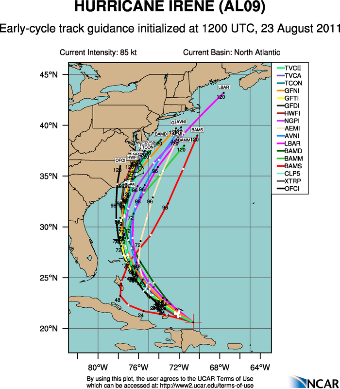
Image of Hurricane Irene's early-cycle track on 23 August 2011, as displayed on the Tropical Cyclone Guidance website.
Dr. Jonathan Vigh has been providing tropical weather guidance for years via his Colorado State University Tropical Cyclone Guidance website. Recently, he has developed a new project site at RAL that replaces the old webpage and adds many new upgrades. The purpose of the TCGP is to 1) foster the development and comparison of more hurricane model guidance for the global tropical cyclone basins and 2) move beyond traditional track and intensity guidance by encouraging the development of forecast guidance for storm structure.
Many locations around the world do not have the luxury of the full suite of model guidance products that the U.S. and Europeans enjoy. Even though some agencies do run model guidance, they are not always efficient at, or even willing to, share this guidance with neighboring countries. Thus, Vigh would like the TCGP to be a venue where scientists, engineers, and agencies can add and extract model guidance data. Such a venue will help both forecasters and researchers by allowing a common platform for real-time comparison of the various guidance products. The TCGP seeks to increase participation by the modeling community so that storm guidance can be shared more effectively. Additionally, Vigh says he believes it is time to move past traditional track and intensity guidance. In a later release of the website (possibly as soon as December 2011), the TCGP will include real-time structure and intensity information garnered from aircraft. The intention is to provide the input data that will be necessary to develop future structure and intensity guidance tools.
The initial release of the TCGP includes an overview map that depicts all active tropical storms in the Atlantic, Eastern Pacific, and Central Pacific basins (other basins will be available later); plots of model guidance featuring storm track and intensity for each storm depicted on the map; and access to the Automated Tropical Cyclone Forecast (ATCF) – formatted data files that contain the model projections of storm track and intensity, along with storm history. Currently, the repository includes model guidance provided by the National Hurricane Center (NHC), the National Weather Service (NWS), the U.S. Navy, Environment Canada, and the UK Met Office. Three different types of guidance are available for each storm: early cycle (models that finish just minutes after calculations of track and intensity have begun), late cycle (those that finish much later), and Global Forecast System (GFS) ensemble track guidance. The GFS ensemble guidance is calculated by perturbing the initial condition of the GFS model several times, providing a way to estimate the range of uncertainty within the model for a particular storm.
One of the most impressive aspects of the TCGP website is its extensive documentation. Each of the site's many features is explained in great detail so that even the most amateur observer can navigate the TCGP with confidence. For any further information or to include your model guidance within the TCGP, please see the documentation on the site, or contact Dr. Jonathan Vigh at jvigh@ucar.edu.
Cody Phillips is a writer and associate scientist for NCAR's Research Applications Program