New Discoveries in Fire Science
RAL scientists are advancing our understanding of wildfires

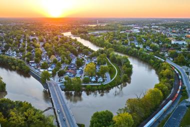
Twenty years ago, a “megafire” was an anomaly. Too extreme to happen again, or so we thought. Yet, in the last 10 years, we’ve seen wildfires consume entire urban centers, devastate local economies, and demolish local communities. Billions of dollars are being spent to recover the vestiges of what once were thriving economies. Fires in North America, Australia, Greece, and other regions have claimed countless lives, devastated wildlife habitats, and caused significant property damage. This is no longer an anomaly, but a trend. Knowing this, scientists have begun the fight from the research side. Knowing when a fire is likely, how fast it will burn, and how far and where it will spread will go a long way toward protecting property and lives.
The latest in our wildfire research:
Fire-Behavior Modeling & Prediction
Fuel-Moisture Content
Forecasting Wildfire Spread - Saving Lives and Property
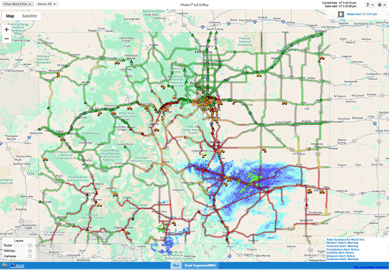
Understanding how wildfires behave – where and how quickly they spread, for example – is critical information for emergency managers, decision-makers, and the public at large. However, making such predictions is no easy task. According to the “fire-behavior triangle” concept, first proposed in the 1970s, there are three key components influencing fire behavior: fuels, topography, and weather. This framework is the basis of state-of-the-art fire behavior models used today. Our scientists not only use coupled fire-atmosphere models to better understand the factors controlling fire spread and behavior, but also customize models to improve their predictive capabilities. These coupled models can represent the complex two-way exchange between a fire and its surrounding atmosphere.
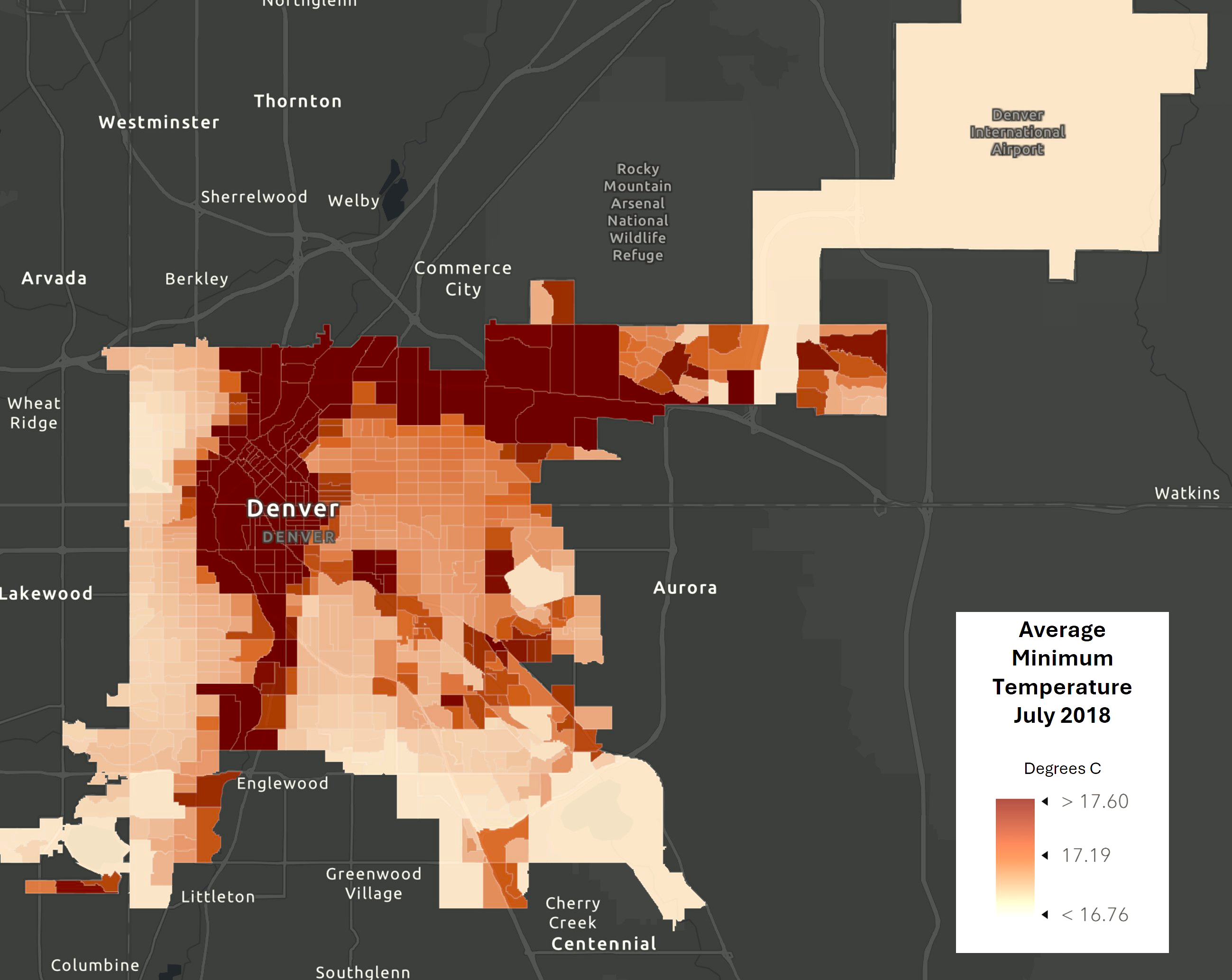
Accurate fuel and weather information, which are necessary inputs to the models, are critically important for accurate predictions of fire behavior. Fuel properties, such as how wet it is and how much there is, can vary drastically in both space and time, especially in complex terrain (such as mountain ranges) and forested regions or after a disturbance event. These factors cause fuel consumption rates to fluctuate over time and area, which then affects the amount of heat, moisture, and smoke released into the air. Weather conditions, like the relative humidity, directly affect the drying or moistening of fuels and, therefore, the speed at which fuels can burn.
Background atmospheric winds, which fan fire spread speed and direction, are in turn, also influenced by the fire’s feedback. One of our research threads has focused on intense, wind-driven fires that have recently devastated communities in California, Colorado, and Hawaii. A common theme with these fires, which spread into the wildland-urban interface, has been a downslope windstorm that rapidly accelerates the fire, ultimately overwhelming emergency response and suppression efforts. Our collaborations aim to understand how the roles of community development, structure hardening, and defensible space might mitigate structure damage. A firebrand (small burning material) parameterization, recently developed by our group, allows us to more closely study the role of embers in fires that spread through neighborhoods and other parts of the built environment.
The more we understand wildfires, the more equipped we will be to exploit the benefits of “good fires,” which are important events to many ecosystems, and limit the destruction from bad fires, which cost the nation hundreds of billions of dollars each year—and in too many cases, human lives.
Resource Links
Pedro Jimenez Munoz
Pedro's expertise is in fire-behavior modeling and fuel characterization drawn from remote-sensing data retrievals.
Tim Juliano
Tim applies his expertise in boundary layers and numerical modeling to understand wildfire-atmosphere interactions, with an emphasis on the downslope winds that drive extreme fire conditions.
Jason Knievel
Jason has led several projects to improve short-term prediction of wildfire behavior through advancements in models, their inputs, and their user interfaces.
Air Quality and Smoke
Tracking Smoke's Impact and Protecting Health
Wildfire activity has widespread impacts on local and remote ambient air quality due to the emissions from combustion and the vertical lofting from pyro-convective events. Studies show that wildfires in the western United States have been severe enough to roll back the benefits of reducing human-caused emissions, resulting in declining air quality in some areas. Additional work has shown that the human-health impacts from wildfires are responsible for approximately 5,000 annual premature deaths and exact a significant financial burden in the hundreds of billions.
Scientists at NSF NCAR have developed several products that help communities understand wildfire impacts on air quality, including collaborative work with the Centers for Disease Control and Prevention, on improving the methods we use to learn how wildfire-tainted air quality has a pronounced impact on human health. As part of this work, we created a 16-year satellite-based reanalysis using WRF-Chem and WRF-CMAQ. This product tracks yearly and seasonal changes in wildfire activity and its effects, providing better insight into how wildfires have influenced air quality in the U.S. since 2005. Newer ongoing projects are being performed at NSF NCAR to explore how ambient pollutants from wildfire infiltrate the built environment (homes, commercial buildings, etc.) to better understand the amount of personal exposure incurred from both near-source and transported wildfire smoke plumes. This project, involving multiple agencies, uses air-quality models to study both outdoor and indoor air pollution. It shows that during wildfires, the group studied in California experienced a significant decline in indoor air quality, regardless of efforts to reduce smoke entering their homes. NSF NCAR scientists have also been working to more fully characterize emissions from varied fuel and ignition types to better characterize wildfire smoke composition. These projects and many others provide improved information to the wildfire-health community and can benefit both researchers and public stakeholders.
Resource Links
Rajesh Kumar
Rajesh focuses on improving deterministic and probabilistic short-term (0-72 hours) air-quality predictions by integrating dynamical models with multi-platform observations.
Forrest Lacey
Forrest uses atmospheric models and observations to explore links between wildland fire activity, air quality, and human health.
Wildfire and Subseasonal-to-Seasonal (S2S) Weather
Smarter Fire Mitigation Efforts
There is an urgent need for tools that can assess current fire mitigation strategies and better predict regional fire activity. Our research developed a new machine-learning model that revealed robust connections between long-term weather conditions and peak fire-season (i.e., summer) and may predict the total burn area across the western U.S. A key novelty of this research was that it established a strong correlation between pre-fire season average weather conditions (in winter and spring) with the summer fire activity, which provided a means to predict broadscale burn area at a subseasonal-to-seasonal (S2S) timescale prior to the peak fire season.
The need for this research is two-fold. First, under the current conditions in the western US—where many regions that experience arid summers are also covered by dense vegetation—the year-to-year changes in dryness and heat largely dictate how much land burns. The value of a machine-learning model that quantifies this relationship is essential for evaluating the effectiveness of wildland fire mitigation practices (e.g., fuels management, prescribed burns, etc.). For instance, prudent fire-hazard management strategies may attempt to decouple long-range weather and fire to reduce the growing fire risks associated with western U.S. drought. The model we developed can reasonably predict burn areas using only pre-fire hydroclimate information. When management strategies decouple the climate-fire relationship, the model shows worsened performance because additional information, beyond just climatology, is essential for predicting the burn area. RAL has initiated an effort in this direction to include S2S numerical weather predictions to predict fire danger at the sub-seasonal horizon. Additionally, models that accurately predict the western U.S. fire hazard prior to the peak fire season can be leveraged to more effectively allocate the resources needed for wildland firefighting.
Resource Links
Ronnie Abolafia-Rosenzweig
Ronnie specializes in using machine learning to quantify how climate factors, such as drought and snowpack, influence regional fire hazard across the western United States.
Cenlin He
Cenlin is actively researching the meteorological and land-surface processes that drive fires as well as fire impacts on land-surface conditions and hydrology.
Focus Areas of Research
Publications
- Wildland Fires in California from 2008 to 2018
- Next-Generation Emissions InVentory Expansion of Akagi et al.
- High Resolution Forecasting of Summer Drought in the Western United States
- For Western Wildfires, the Immediate Past Is Prologue
- Winter and spring climate explains a large portion of interannual variability and trend in western U.S. summer fire burned area
Title
Meet our Wildfire Scientists
Ronnie Abolafia-Rosenzweig
Ronnie specializes in using machine learning to quantify how climate factors, such as drought and snowpack, influence regional fire hazard across the western United States.
Stefano Alessandrini
Stefano specializes in post-processing techniques to improve fire-danger forecasts at subseasonal to seasonal timescales.
Masih Eghdami
Masih works on coupled fire–atmosphere modeling, integrating fire-behavior dynamics with operational weather-prediction systems, and studying how fire emissions influence cloud microphysics and regional weather
Maria Frediani
Maria specializes in modeling fire behavior of wildfires, fire-weather, and ember showers in high fire risk conditions.
Cenlin He
Cenlin is actively researching the meteorological and land-surface processes that drive fires as well as fire impacts on land-surface conditions and hydrology.
Pedro Jimenez Munoz
Pedro's expertise is in fire-behavior modeling and fuel characterization drawn from remote-sensing data retrievals.
Tim Juliano
Tim applies his expertise in boundary layers and numerical modeling to understand wildfire-atmosphere interactions, with an emphasis on the downslope winds that drive extreme fire conditions.
Lee Kessenich
Lee works with future fire weather and extremes, with an emphasis on convergent science aiming to make climate data accessible to a variety of end users including fire management and policymakers.
Jason Knievel
Jason has led several projects to improve short-term prediction of wildfire behavior through advancements in models, their inputs, and their user interfaces.
Rajesh Kumar
Rajesh focuses on improving deterministic and probabilistic short-term (0-72 hours) air-quality predictions by integrating dynamical models with multi-platform observations.
Forrest Lacey
Forrest uses atmospheric models and observations to explore links between wildland fire activity, air quality, and human health.
Seth McGinnis
Seth's work on fire focuses on modeling the relationship between climate & weather, simultaneous large wildfires, and fire-management resource strain in the Western US.
Christopher Rozoff
Christopher works toward improving the prediction of smoke plumes and air quality around and downstream of major wildfires.
Shima Shams
Shima develops remote sensing and data assimilation frameworks to assess post-fire recovery, air quality, and environmental change, supporting science-informed decision-making.