Where the Rubber Meets the Road
NCAR Technology Put to the Test on Treacherous Winter Roads
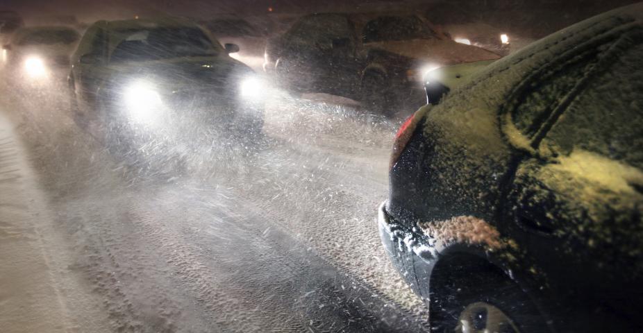
Imagine cruising down Interstate 80 in Wyoming at the speed limit, 80 mph, when you suddenly hit a fog bank or an invisible layer of ice. What would you do? Slam on the brakes and pray? Or you’re a commercial trucker hauling a large shipment and your trailer is getting slammed by gusts – do you pull over or persevere and hope the winds die down?
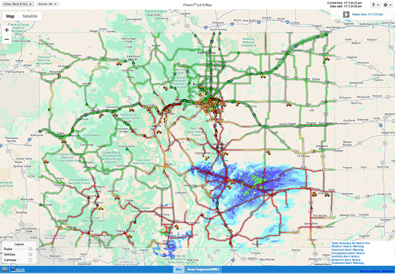
Pileups on I-80 under these conditions, which typically involve both commercial and passenger vehicles, may be a thing of the past. This winter, NCAR is partnering with the Wyoming Department of Transportation (WYDOT) in the WYDOT Connected Vehicle Pilot Deployment Program, a program focused on improving road safety, mobility and efficiency. This pilot program is using the NCAR-developed Pikalert® system to gather critical weather data and predict road conditions based on the data.
Pikalert® creates road and atmospheric hazard products for a variety of users, but for this project, it is testing its information system on the state of Wyoming’s fleet and the commercial trucking industry that uses I-80 during winter months. It is being conducted along the I-80 corridor which is heavily used by large semi-trucks in spots where significant winds have been known to cause truck blow-over events.
The National Center for Atmospheric Research (NCAR) has been partnering with the Federal Highway Administration (FHWA) for many years, developing, testing and deploying a connected vehicle system to assist drivers and DOTs with decision-support tools in weather-hazardous environments. Running in real time, Pikalert® has a number of components: the Vehicle Data Translator (VDT), the Enhanced Maintenance and Decision Support System (EMDSS), and the Motorist Advisory and Warning application (MAW).
For the Wyoming project, NCAR scientists are analyzing the on-board forecasts and distress notifications (such as forward collision warning), and how well it communicates to drivers. Trucks used by the Wyoming DOT fleet and commercial trucks act as the observing equipment, gathering data on-board (i.e. windshield wiper use/speed, anti-lock brake use, and speed of the vehicle). Information is also being gathered on the weather conditions through observing systems on the roadside every mile (i.e. air temperature, humidity, winds).
“Putting massive amounts of data into a useable format was the challenge,” said Amanda Anderson, scientist at NCAR.
The volumes of data fed into Pikalert® by these moving and stationary platforms are then synthesized to create a forecast using a blend of forecast models, in a user-friendly decision-support system. The system automatically updates conditions and provides a new forecast every five minutes.
This pilot program, which will run through next winter, can be adopted by other state DOTs. NCAR will continue to work with state partners in Wyoming, as well as Minnesota, Michigan, Colorado, and Alaska, to create enhanced functionality in the Pikalert® System. More states throughout the U.S. challenged by road weather hazards could also benefit from this technology. If a region suffers from such road hazards as heavy rains, hail, flooding, high winds, Pikalert® could provide much-needed information about conditions. Traffic in Atlanta, for example, is notorious for getting snarled with just a ½-inch of snow. Maintenance fleets using Pikalert® could plan accordingly. Future work utilizing Pikalert® could include railroads and high summer temperatures warping tracks and high winds blowing over railroad cars.