NCAR Bids Farewell to Experimental ADDS
Pilots can assess flight hazards on Operational ADDS
June 30th will mark the successful completion of the experimental arm of the Aviation Digital Data Service (ADDS), a 20-year inter-agency collaboration between the Federal Aviation Administration’s (FAA) Aviation Weather Research Program (AWRP), the National Center for Atmospheric Research’s (NCAR) Research Applications Laboratory (RAL), and the National Oceanic and Atmospheric Administration’s (NOAA) Aviation Weather Center (AWC). Pilots of all stripes used and valued it as it provided improved aviation weather products, interactive visualizations, and real-time data services they needed and requested.

The Experimental ADDS website will be shut down but the Operational ADDS website, http://aviationweather.gov/, will continue to serve the weather needs of the aviation community.
Before ADDS

For current, in-flight, and destination weather conditions, pilots depend on a weather briefing before taking to the skies. In the old days, these would look like rip-and-read alphanumeric reports using dial-up modems. These reports provided an overwhelming amount of information to wade through: temperature, winds, visibility, freezing rain, turbulence, thunderstorms, etc. Not only were they cumbersome, at times they were fraught with error. Pilots needed information that synthesized the volumes of data they were required to ingest before taking off.
Managing Real-Time Weather Data
By the mid-1990s, when people were realizing the potential of the Internet, NCAR approached the FAA with a proposal to get weather information to pilots in a novel fashion. By tapping into NCAR’s scientific and engineering expertise, and its earlier success of identifying and forecasting microbursts, it proposed to provide the new gridded aviation products along with the traditionally used advisories and reports, such as AIRMETs, SIGMETs and METARs, and provide them in a user-friendly, easy-to-read, format. The FAA agreed to fund the work and the Aviation Weather Center agreed to operate the site. Initially, the FAA regulatory organization was skeptical. Information from the Internet, they believed, was not to be trusted. It took time and a level of comfort, but eventually the FAA embraced the use of the Internet, developing a process to use it (Qualified Internet Content Provider or QICP), which is still used today. Operational ADDS was born. Gone were the days of beeping modems, mountains of teletype texts and information overload.
Since then, a long and fruitful relationship grew from the R&D side in Boulder, CO to the operations side at NOAA’s Aviation Weather Center (AWC) in Kansas City, MO. Experimental ADDS introduced prototype weather products to the aviation community while gathering feedback on the products' utility from the users. Following the rigorous review and approval process, products got the green light for operational use. “Experimental ADDS lets users kick the tires and give us feedback before moving to operational status,” said Bob Barron, Deputy Director for Engineering of NCAR’s Aviation Applications Program.
Arnaud Dumont, software engineer and ADDS team lead, agreed. “What makes ADDS unique is that it took all of the traditional products used for years and made them easier to use. Four-D tools now allow the user to slice, dice, zoom and overlay grids with traditional products.”
Spinoff of ADDS: Helicopter Emergency Medical Services (HEMS) Tool
“Every Helicopter Air Ambulance pilot in the country has embraced the HEMS Weather Tool as one of their primary go-to weather reporting systems.”
Rex Alexander, Senior Consultant, HeliExperts International LLC
In May, the Helicopter Emergency Medical Services (HEMS) tool became operationally available on the National Weather Service Aviation Weather Center’s website (http://www.aviationweather.gov/hemst). HEMS is a natural extension of NCAR’s ADDS program, and provides helicopter pilots easy-to-use web access to a variety of critical aviation weather information. It was developed at the request of the FAA after a 2006 review of rescue helicopter crashes revealed that a lack of detailed weather information was often a factor.
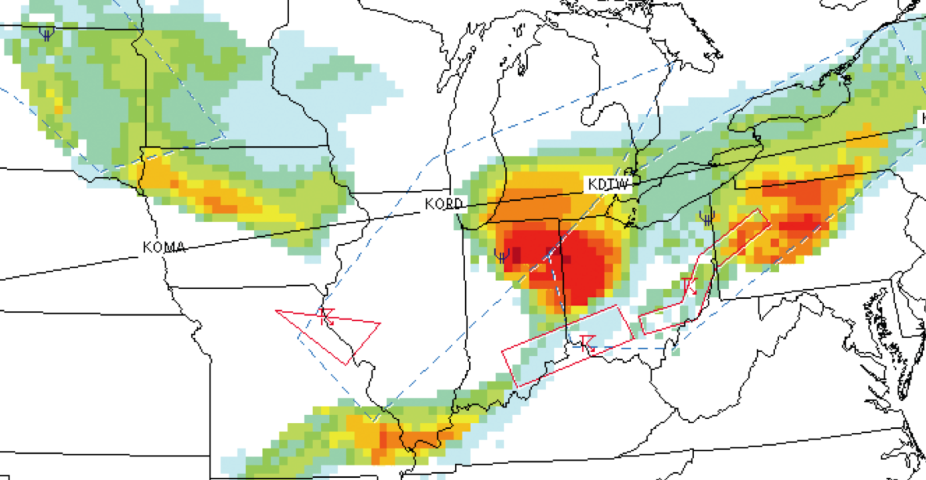
Like ADDS, the HEMS Tool interactively displays high resolution grids of critical weather parameters: ceiling, visibility, flight category, winds, icing severity, relative humidity, temperature, radar, satellite, G-AIRMETs, SIGMETs, METARs, TAFs, PIREPs, NWS warnings, and Center Weather Advisories (CWAs). Overlays include navigational aids, airports and heliports for the entire United States. More detail is revealed as you zoom in and individual layers can be turned on or off independently.
The work isn’t done
NCAR will continue to be a leader in aviation weather research and development. Its model of focusing on the end-users’ requirements and input at each step along the development path has a proven track record. Development of useful aviation applications requires a strong connection between its work and the needs of aviators, and current R&D efforts to address those needs include in–flight icing; snowfall and freezing precipitation; convective storm nowcasting and forecasting; atmospheric turbulence; ceiling and visibility; and oceanic weather. While Experimental ADDS has graduated to the operational side, much more work in aviation weather hazards at NCAR continues.
Laura Curtis is a writer for NCAR's Research Applications Laboratory