Forecasting Systems
Forecasting Systems
High-resolution, short-term forecasts of thunderstorms provide critical information for a wide range of users, including the aviation community, ground transportation, urban emergency and water resources management groups, recreation facilities, construction industries, and the military, that assists them to safely and efficiently deploy resources. However, achieving reliable and accurate convective weather forecasts remains a scientific challenge due to uncertainty in grasping initial conditions, shortcomings in model physics and computational capabilities, and limitations of our understanding of how nature works.
The forecast skill of observation-driven expert systems decreases rapidly with increasing lead-time, while numerical weather prediction models exhibit a limited forecast ability within the first few hours after initialization primarily due to spin-up problems. Furthermore, forecast methodology and display systems have to be tuned to the needs of different users—for example, a line of severe convective storms predicted in the wrong place may be perceived as a bad forecast from a water resources manager (e.g., dam operator), yet the same forecast might be quite good for an en-route air traffic control manager.
RAL conducts research and development geared toward short-term forecasting of high-impact weather. The objective is to enhance existing and facilitate new capabilities of monitoring (i.e., analysis), nowcasting (under two hours), and forecasting (two hours and beyond) weather-related conditions that pose a hazard or threat to human safety, transportation on land, water, and in the air, and to infrastructure.
THUNDERSTORM PREDICTION
RAL has a long history in thunderstorm research advancing the understanding of dynamic, thermodynamic, and microphysical processes related to severe weather. The development of storm prediction capabilities builds on extensive experience gained through analysis of observations, data assimilation, numerical modeling, diagnostic evaluation and forecasting. The storm predictions may be of deterministic or probabilistic nature, the latter capturing forecast uncertainty associated with longer outlooks. Key capabilities include the following:
- Thunderstorm Identification, Tracking, Analysis and Nowcasting (TITAN)
A radar-based capability to objectively identify, track, and forecast thunderstorms. - AutoNowcaster (ANC)
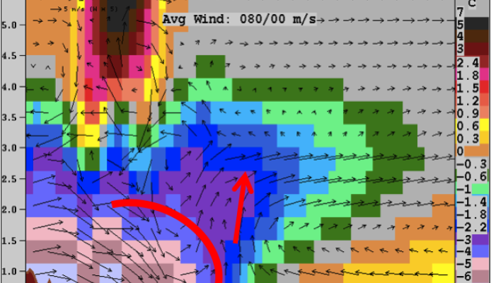
A storm monitoring and prediction capability that utilizes information from radar, satellite, numerical weather prediction model, upper air soundings, and surface observations to predict storm initiation and evolution. A unique feature is that the system enables human interaction for enhanced predictions. - Fine-Scale Analysis and Nowcast System (FINECAST)
A rapidly updating, high-resolution, four-dimensional variational analysis of radar or lidar, numerical weather prediction model, upper air and surface observations to capture the environmental conditions and predict storm initiation and evolution. - Consolidated Storm Prediction for Aviation (CoSPA)
Analysis and forecast of storm intensity and echo tops for aviation developed based on a collaborative effort between NCAR's Research Applications Laboratory, MIT Lincoln Laboratory, and NOAA ESRL's Global Systems Division. - Probabilistic Storm Prediction
Development of tools that can distill large amounts of observational and ensemble model data into a probabilistic prediction of convective storms with attributes that are likely to impact air traffic flows across the National Airspace System (NAS). - Ensemble Weather Forecast Translation into Impact Prediction
New concepts of how ensemble weather forecasts can be utilized to effectively plan for anticipated weather impacts.
LIGHTNING THREAT NOWCASTING
Lightning poses a particular safety risk to people outdoors whenever thunderstorms are nearby. RAL has developed a radar-based capability to diagnose the potential for lightning to occur. The capability is calibrated using observed lightning data and can be tailored to specific user needs.
WINTER STORM PREDICTION
Winter weather can be particularly impactful to aviation, as it significantly slows down operations due to necessary snow and ice removal from apron, taxi- and runways, and de-/anti-icing requirements for aircraft before takeoff. RAL has developed several capabilities to help stakeholders more effectively deal with winter weather impacts. Key capabilities include the following:
- Maintenance Decision Support System (MDSS)
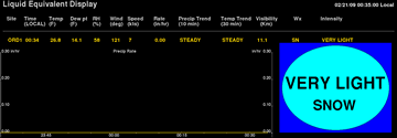
A capability to support effective winter maintenance decisions (treatment types, timing, rates, and locations) for controlling snow and ice buildup on roadways during winter weather events. - Aircraft Ground Deicing
A state-of-the-art, integrated system to depict accurate, real-time nowcasts of snowfall rate, plus current temperature, humidity, wind speed and direction, to support aircraft deicing operations.
OCEANIC CONVECTIVE HAZARD GUIDANCE
Remote, oceanic regions have severely limited data availability and, therefore, have few, if any, high resolution and rapidly updating weather products that indicate current and future locations of aviation weather hazards, such as produced by convective storms. Convective storms impact the safety and efficiency of oceanic aircraft operations by producing turbulence, icing and lightning hazards, and thereby necessitating aircraft rerouting while inflight, leading to higher fuel costs and delays. RAL has developed nowcasting and forecasting capabilities to support more effective decision making and flight routing.


Contact
Scott Landolt
Director, Transportation Meteorology Applications Program