Global Weather Notification
Real-Time, Cutting-Edge Weather Hazard Information
The Global Weather Notification system is a novel way to provide pilots with real-time, cutting-edge weather hazard information and to keep them informed of rapidly developing adverse weather conditions. The system brings pilots' attention to hazardous conditions beforehand, allowing them to take measured, preemptive, responses to ensure safe and efficient flight operations.
GlobalWeatherNote (GWN) is a ground based system that anticipates whether an aircraft will soon be in close proximity to predicted or observed weather events. It can provide significant benefit to pilots by reducing their need to analyze weather data while en-route, reducing bandwidth usage in the cockpit, and bringing a pilot’s attention to adverse weather that may be rapidly developing. Running on the ground allows accommodating as many aircraft as needed, giving it immediate access to the latest high resolution weather information, and minimizes cockpit bandwidth usage. The system works with any tracked aircraft, but to receive notifications in the cockpit, the pilot must have some type of onboard connection system.

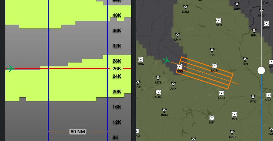
GlobalWeatherNote predicts an aircraft's future path and creates a projection notification area
More Planning Time
The algorithm defines a projection area for each aircraft. The leading edge of the area is the projected aircraft location and a typical projection area width is 50 NM wide, or 25 NM perpendicular in both directions from the predicted aircraft’s flight track. The length of the projection area depends on the speed of the aircraft, the update frequency of the weather product, and the location where the aircraft is flying. At a minimum, the length of the area should cover the aircraft’s flight path until the next anticipated update of the weather information. For transoceanic or other long haul flights, a longer projection area can be used to provide the aircrew more time to plan for a weather event along the route.

Example GlobalWeatherNote Message
Each weather type has predefined categories and thresholds defined within the system, but also allows for setting individualized thresholds for a given flight. These thresholds must be set carefully based on the temporal and horizontal resolution of the weather product to prevent over-notification of a particular weather type. The system counts the number of weather values in each defined category that fall within the aircraft’s projection area. The highest category in which a notification threshold is met is used as the notification for the aircraft. If no threshold is met, then no message is created. Low categories, such as light turbulence or light convection, result in a generalized notification message for the area ahead, e.g., “Light Turbulence in area ahead”. For more hazardous categories, the system will calculate the closest location of the adverse weather to the aircraft and include it in the notification message, e.g., “Moderate Turbulence at <location>”. The location format can be either a waypoint with radial and distance or a latitude/longitude pair. This information gives the aircrew a quick way to identify the location of the adverse weather, assess their current distance from it, and determine optimal mitigation strategies.
Straightforward Notifications

Example of GlobalWeatherNote integrated into a EFB weather display
Notification messages that are generated are packaged into an easy-to-use XML format to be delivered to each aircraft. The XML format allows packaging of not just the notification text, but also includes aircraft meta-data information and the projection information that was used to generate the notification. This additional information allows the message to be used in multiple ways; printed as a simple text message to the aircrew, displayed in a weather app, and/or integrated into an Electronic Flight Bag (EFB). In the case of an app or EFB, the pilot is able to view the predicted aircraft location and the projection area directly overlaid on the weather information.