NOAA Community Modeling Workshop & Strategic Implementation Plan (SIP) Coordination Workshop
-
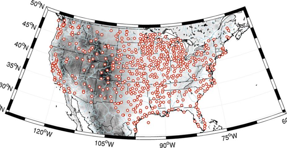
As part of NASA and NREL funded projects, a new method has been proposed and demonstrated for the long-term estimate of the wind speeds at a target site, a key step in wind resource assessments (Vavyve et al. 2013, Zhang et al. 2015). Analog ensemble (AnEn) techniques have been used with success for short-term weather predictions (e.g., Delle Monache et al. 2013). In the context of the wind resource assessment, the analog-ensemble method draws on the information contained in the historical data of multiple physical quantities over the period these data overlap with the observations (known as training period; typically 365 days) of the quantity of interest (known as predictand; the wind speed in this study). The relationships derived within the training period are then applied to reconstruct the on-site wind speed over the period for which there are no observations (hereafter referred to as reconstructed period, e.g., the past 20 years before the measurement campaign started).
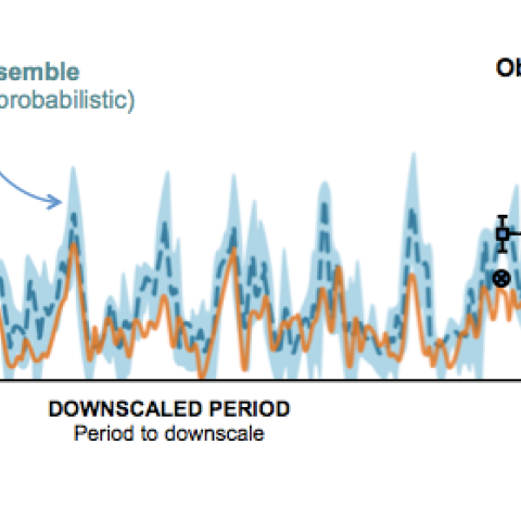
Sketch of the functioning of the Analog Ensemble (AnEn) method for one analog predictor, the analog trend reduced to one time step, and when retaining the best three analogs.
More precisely, this is a three-stage process that is executed independently at every target site for every hour t of the reconstructed period, as sketched in the figure. First, the historical value of multiple physical quantities (known as analog predictors; e.g. wind speed itself, wind direction, pressure, etc.) is retrieved for a time window (known as an analog trend) centered around time t (black dot in Fig. 1). The analog predictors are selected beforehand based on their known or anticipated correlations to the predictand. Second, other historical cases with conditions similar to those in the target window are identified (known as analogs) by looking at a time window (known as analog search window) centered around the same hour of the day for every day in the training period, and ranked by closeness of match. Analogs may therefore come from any day the training period. Using multiple predictors helps distinguish the analogs by identifying specific weather regimes relevant to the predictand. Third, the K best analogs (K the number of analogs; black circles) are selected, and the corresponding observed values of the predictand are retrieved (black squares). The latter constitute the ensemble members for hour t.
The final result is the analog ensemble, i.e., a set of K wind speed values for every hour t of the reconstructed period. The assumption is that if analogs are found, their errors will likely be similar to the error of the historical time step to reconstruct, error that can then be inferred from them. As shown by Vavyve et al. (2013) and Zhang et al. (2015):
The Climate Risk Management engine (CRMe) is an extensible, efficient NCL-based code set (with capability to integrate R packages) used to process and analyze large climate data sets (daily or monthly) from a variety of differernt sources (observations, model output) and on any horizontal resolution (global, regional, local). CRMe can handle various processing tasks such as:
CRMe provides consistent data provenance by preserving metadata from source datasets and implementing a structured metadata schema with controlled vocabulary. These provisions enable downstream applications (such as Open Climate GIS) and enable for controlled extensible search.
 - Diversity of Climate Indicatorsfor analysis platforms, screening tools and dashboards")
CRMe implements a simple form of workflow control and is flexible to be run on a desktop, a server, or a supercomputer. The result is that CRMe can take a ~1 TB dataset of high resolution global observational data and compute 1600+ calculation datasets and visualize these in a matter of hours.
CRMe employs workflow parallelization by dataset, so scores of climate model datasets can be run simultaneously over multiple climate periods. CRMe can process 10+ TB of CMIP5 climate data into several hundred sector-oriented indices with a turn-around time of a few days.
CRMe supports "Big Data"-sized problems (e.g., 100+ years of global data at half degree grid spacing, or 60+ years of global data at quarter degree grid spacing).
These capabilities, coupled with the CRMe Viewer, provide powerful new ways to browse and compare large sets of climate data in past and future climates.

4-D relaxation ensemble Kalman Filter (4D-REKF) data assimilation and forecasting system. 4D-REKF integrates and leverages the cutting-edge ensemble Kalman filter (ENKF) data assimilation scheme, which is currently being studied by many leading weather institutions and universities. 4D-REKF represents a new way to extend the traditional (intermittent) EnKF data assimilation method to a 4D continuous data assimilation paradigm that avoids the dynamic shocks associated with the intermittent EnKF processes. Through this project, NCAR will collaborate with SGCC/CEPRI to apply, specialize, and advance the 4D-REKF 4-D data assimilation scheme in the development of power-grid numerical weather prediction capabilities. The overarching goal of 4D-REKF is to build up a strong backbone technology of RTFDDA, Ensemble-RTFDDA, Climate-FDDA, and FDDA-LES modeling technologies and produce robust weather information to support electric power production, transmission, and services of SGCC.
Please direct questions/comments about this page to:
Director, Weather Intelligence and Security Program
RTFDDA-LES extends real-world numerical weather prediction to large-eddy-simulation (LES) scales, with grid sizes down to ~30m. The NCAR WRF-based RTFDDA system is formulated for simultaneously nesting-down from mesoscale to LES modeling scales. The WRF “observations-nudging”-based FDDA is activated on the coarse meshes, which continuously assimilates diverse synoptic and asynoptic weather observations and thus provides accurate boundary forcing to the high-resolution modeling on fine-mesh LES model domains. The WRF-RTFDDA-LES system is described in Liu et al. (2010) in details. RTFDDA-LES will be employed to study and forecasting severe winds in the critical segments of the ultra-high-voltage power transmission lines in complex terrain areas.

Real-time ensemble RTFDDA forecasting system combines real-time WRF-based FDDA technologies and a probabilistic forecast calibration technology for producing reliable real-time probabilistic wind/weather data assimilation and forecasting. The probabilistic mesoscale weather forecasting of this real-time system can provide more accurate forecasts of various weather variables and weather phenomena (lightning, severe winds, torrential rain, blizzard, icing, etc.) that threaten electric-power grid safety and generate important information of flow-dependent uncertainties of these weather variables and phenomena. The NCAR real-time ensemble FDDA systems have been deployed and used to support routine tests at the U.S. Army test ranges, Xcel Energy for wind-power integration, and also in northwestern China for wind-power forecast by SGCC.
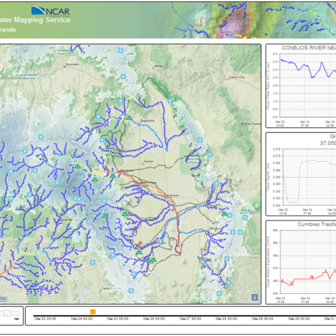
The WRF-Hydro® HydroInspector® is a state-of-the-art Web Mapping Service (WMS) that allows users to manipulate and interact with a host of hydrologic observation and hydrologic model output data. The HydroInspector® software is an internet-based toolset for visualizing and analyzing output from the WRF-Hydro® modeling system, and other hydrologic models, as well as for comparing model output against other real-time observational data. It allows users to directly interact with the data and create compelling visualizations of surface hydrologic data such as snowpack, soil moisture, evaporation, precipitation and streamflow that are tailored specific time periods, spatial domains or station locations.
Please contact us for more information on partnering to create HydroInspector applications.