Workshop on Extreme Heat and Ozone
-
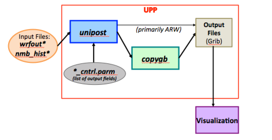
The Unified Post Processing System (UPP) was deleveloped at the National Centers for Environmental Prediction (NCEP) and is used operationally for models maintained by NCEP. The NCEP Unified Post Processor has replaced the WRF Post Processor (WPP). The UPP software package is based on WPP but has enhanced capabilities to post-process output from a variety of NWP models, including WRF-NMM, WRF-ARW, Non-hydrostatic Multi-scale Model on the B grid (NMMB), Global Forest System (GFS), and Climate Forecast System (CFS).
The community EnKF system is a Monte-Carlo algorithm for data assimilation that uses an ensemble of short-term forecasts to estimate the background-error covariance in the Kalman Filter. It is designed to be flexible, state-of-art, and run efficiently on various parallel computing platforms. The EnKF system is in the public domain and is freely available for community use.
The JNTP is currently supporting the Gridpoint Statistical Interpolation (GSI) system (variational and Ensemble-Variational (EnVar)) and the Ensemble Kalman Filter (EnKF) data assimilation system (ensemble based). Both are operational data assimilation systems used by multiple applications at NOAA, NASA, AF and other facilities and agencies (e.g., HWRF, GFS, RAP, NEMS, etc).
This project started in 2009 with a joint effort between the JNTP (under the auspices of the Developmental Testbed Center) and NCEP/EMC to expand the operational GSI data assimilation system to the research community, with the sponsorship of NOAA, AF and NCAR (supported by National Science Foundation (NSF)). This effort was expanded to the operational EnKF system in 2014. The objectives of this effort are to provide operational data assimilation capabilities to the research community, open the pathway for the research community to contribute directly to daily operations, and, eventually, accelerate transitions from research to operations, which is in line with the mission of the sponsors and the DTC.
This effort has produced a code management framework to unify the distributed development and operational applications for GSI starting from 2010 and, additionally, EnKF starting from 2015. A joint data assimilation scientific steering and code review committee was formed, including major development teams for both systems across the United States. The GSI and EnKF systems and their supplemental libraries and auxiliary files are managed in the Community Data Assimilation Repository under version control (using Subversion). Targeted code tests are organized to maintain code robustness and integrity. General community support is provided through annual code releases, documentation, tutorials, a helpdesk, and assistance with code transitions and tests. Community researchers and users are encouraged to collaborate with the DTC and/or the JNTP to further advance GSI and associated data assimilation techniques, following the same code management procedures as internal developers. The User’s Page for GSI and EnKF can be found at the following links:
The Flight Path Tool (FPT) is a comprehensive, interactive, geographical display that brings together all of the weather products available on ADDS. It runs as a desktop application on your computer for maximum performance.
The Flight Path Tool can overlay multiple fields of interest: icing (probability, severity, and super-cooled large drops), turbulence potential, convective diagnosis and forecast, ceiling, visibility, flight category, winds, relative humidity, temperature, radar (base and composite reflectivity), satellite observations (visible, infra-red, and water vapor wavelengths), AIRMETs and SIGMETs, METARs, TAFs, and PIREPs.
All 3D data can be sliced horizontally at selected flight levels or vertically along a flight path. All data can be animated in time.
The tool lets you zoom in to any location on the globe. It automatically switches to the most appropriate projection for the viewed area. High-resolution basemaps show selectively more detail as you zoom in.
In addition, the Flight Path Tool can create vertical cross sections along your flight route.
Preferred views can be saved for quick recall later.

...
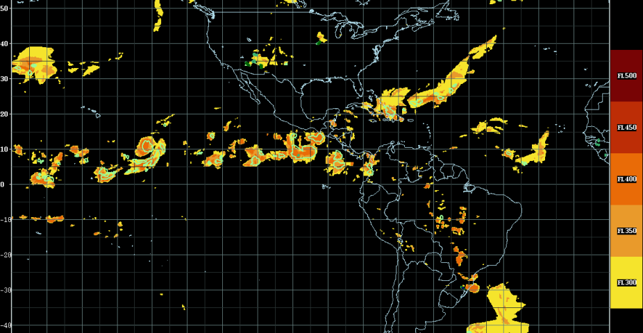
Oceanic Convection & Nowcasting Operations
The Research Applications Laboratory is addressing oceanic weather needs for aviation through the development of convection diagnostic products. These products are the Cloud Top Height (CTH) and the Convection Diagnosis Oceanic (CDO). Both use geostationary satellite data as a primary input with the CDO also utilizing lightning data. These two products focus on the needs of pilots, dispatchers, air traffic managers and forecasters within the oceanic aviation community.